Marion Township, Pike County, Ohio
| Madison Township, Richland County, Ohio | |
|---|---|
| Township | |
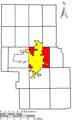
 Location of Madison Township (red) in Richland County, next to the city of Mansfield (yellow). | |
| Country | United States |
| State | Ohio |
| County | Richland |
| Area | |
| • Total | 15.7 sq mi (40.6 km2) |
| • Land | 15.7 sq mi (40.6 km2) |
| • Water | 0.0 sq mi (0.0 km2) |
| Elevation | 1,211 ft (369 m) |
| Population (2000) | |
| • Total | 14,680 |
| • Density | 935.4/sq mi (361.1/km2) |
| Time zone | Eastern (EST) (UTC-5) |
| • Summer (DST) | EDT (UTC-4) |
| For infobox source see[1] | |
Contents
Municipality Well Data
| Well ID | Operator Name | Permit Date | Spud Date | Configuration | License Status |
|---|---|---|---|---|---|
| 34-131-20006 | HISTORIC OWNER | 1953-11-04 | 1953-11-10 | Vertical | Historical Production Well |
| 34-131-20007 | HISTORIC OWNER | 1900-01-01 | Vertical | Unknown status | |
| 34-131-20008 | HISTORIC OWNER | 1954-11-20 | Vertical | Historical Production Well | |
| 34-131-20009 | HISTORIC OWNER | 1954-07-28 | Vertical | Historical Production Well | |
| 34-131-20010 | HISTORIC OWNER | 1954-06-22 | Vertical | Plugged and Abandoned | |
| 34-131-20011 | HISTORIC OWNER | 1954-06-15 | Vertical | Historical Production Well | |
| 34-131-20013 | HISTORIC OWNER | 1955-05-10 | Vertical | Historical Production Well | |
| 34-131-20014 | HISTORIC OWNER | 1954-12-29 | Vertical | Historical Production Well | |
| 34-131-20015 | HISTORIC OWNER | 1955-01-27 | Vertical | Historical Production Well | |
| 34-131-20018 | HISTORIC OWNER | 1956-01-15 | Vertical | Historical Production Well | |
| 34-131-20023 | HISTORIC OWNER | 1962-10-05 | 1962-09-27 | Vertical | Plugged and Abandoned |
| 34-131-20037 | HISTORIC OWNER | 1967-12-22 | 1968-01-22 | Vertical | Historical Production Well |
| 34-131-20042 | RAPP DONNA | 1981-03-04 | 1981-08-25 | Vertical | Domestic Well |
| 34-131-20044 | MIDWEST TRADING CO INC | 1981-03-05 | 1981-05-14 | Vertical | Domestic Well |
| 34-131-20045 | DAVIS JOHN L | 1981-03-04 | 1981-08-20 | Vertical | Domestic Well |
| 34-131-20050 | MAJ | 1981-03-10 | 1981-08-31 | Vertical | Final Restoration |
| 34-131-20051 | BRUNNER FARM | 1981-03-10 | 1981-09-08 | Vertical | Domestic Well |
| 34-131-20059 | MAJ | 1981-07-13 | Vertical | Not Drilled | |
| 34-131-20063 | PICKLESIMER MARTIN | 1981-10-20 | 1981-11-02 | Vertical | Domestic Well |
| 34-131-20068 | ROBINSON JAMES | 1981-10-23 | 1981-11-23 | Vertical | Domestic Well |
| 34-131-20074 | SLONE GEORGE | 2000-02-11 | 1982-02-01 | Vertical | Domestic Well |
| 34-131-20080 | BROWN JOHN RUTH A | 1983-03-10 | 1983-04-27 | Vertical | Domestic Well |
| 34-131-20082 | BROWN ROY VANCIL | 1983-03-29 | 1983-04-23 | Vertical | Domestic Well |
| 34-131-20090 | KNOX ENERGY INC. | 2011-12-05 | 2007-11-05 | Vertical | Final Restoration |
| 34-131-20091 | PAXTON MADISON LLC | 2007-09-05 | 2007-10-25 | Vertical | Final Restoration |
| 34-131-20092 | KNOX ENERGY INC. | 2011-12-05 | 2007-10-30 | Vertical | Final Restoration |
| 34-131-20093 | BRUST CHRIS | 2011-12-05 | 2007-10-26 | Vertical | Domestic Well |
| 34-131-60010 | HISTORIC OWNER | Vertical | Historical Production Well | ||
| 34-131-60011 | HISTORIC OWNER | 1900-01-01 | Vertical | Historical Production Well | |
| 34-131-60012 | HISTORIC OWNER | Vertical | Not Drilled | ||
| 34-131-60013 | HISTORIC OWNER | Vertical | Not Drilled | ||
| 34-131-60014 | HISTORIC OWNER | Vertical | Not Drilled | ||
| 34-131-60038 | HISTORIC OWNER | Vertical | Historical Production Well | ||
| 34-131-60039 | HISTORIC OWNER | Vertical | Plugged and Abandoned | ||
| 34-131-60040 | HISTORIC OWNER | 1900-01-01 | Vertical | Plugged and Abandoned | |
| 34-131-60041 | HISTORIC OWNER | Vertical | Plugged and Abandoned | ||
| 34-131-60042 | HISTORIC OWNER | Vertical | Plugged and Abandoned | ||
| 34-131-60043 | HISTORIC OWNER | Vertical | Historical Production Well | ||
| 34-131-60064 | HISTORIC OWNER | 1900-01-01 | Vertical | Historical Production Well |
For data sources see[2]
References
- ↑ "Madison Township, Richland County, Ohio#". Wikipedia. Retrieved 2021-01-12.
- ↑ "Risk Based Data Management System". Ohio Department of Natural Resources. 2020-11-16. Retrieved 2020-11-16.