Trenton Township, Delaware County, Ohio
| Stock Township, Noble County, Ohio | |
|---|---|
| Township | |
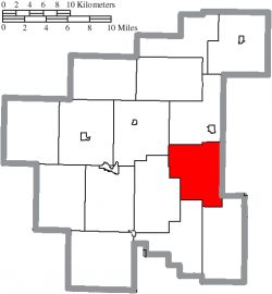
 Location of Stock Township in Noble County | |
| Country | United States |
| State | Ohio |
| County | Noble |
| Area | |
| • Total | 24.6 sq mi (63.8 km2) |
| • Land | 24.6 sq mi (63.8 km2) |
| • Water | 0.0 sq mi (0.0 km2) |
| Elevation | 1,001 ft (305 m) |
| Population (2000) | |
| • Total | 383 |
| • Density | 15.5/sq mi (6.0/km2) |
| Time zone | Eastern (EST) (UTC-5) |
| • Summer (DST) | EDT (UTC-4) |
| For infobox source see[1] | |
Contents
Municipality Well Data
| Well ID | Operator Name | Permit Date | Spud Date | Configuration | License Status |
|---|---|---|---|---|---|
| 34-041-20019 | HISTORIC OWNER | 1963-11-01 | 1963-11-27 | Vertical | Plugged and Abandoned |
| 34-041-20066 | HISTORIC OWNER | 1964-05-22 | 1964-05-20 | Vertical | Plugged and Abandoned |
| 34-041-20145 | HISTORIC OWNER | 1964-07-31 | 1964-08-03 | Vertical | Plugged and Abandoned |
| 34-041-20150 | HISTORIC OWNER | 1964-08-14 | 1964-08-12 | Vertical | Plugged and Abandoned |
| 34-041-20163 | HISTORIC OWNER | 1964-09-04 | Vertical | Plugged and Abandoned | |
| 34-041-20171 | OXFORD OIL | 1988-01-07 | 1964-09-23 | Vertical | Final Restoration |
| 34-041-20172 | HISTORIC OWNER | 1964-09-18 | 1964-09-13 | Vertical | Plugged and Abandoned |
| 34-041-20183 | HISTORIC OWNER | 1964-09-25 | 1964-09-19 | Vertical | Plugged and Abandoned |
| 34-041-20194 | HISTORIC OWNER | 1964-10-16 | Vertical | Plugged and Abandoned | |
| 34-041-20196 | HISTORIC OWNER | 1964-10-23 | 1964-11-12 | Vertical | Plugged and Abandoned |
| 34-041-20198 | HISTORIC OWNER | 1964-10-30 | 1964-10-30 | Vertical | Plugged and Abandoned |
| 34-041-20202 | HISTORIC OWNER | 1964-10-30 | 1964-11-16 | Vertical | Plugged and Abandoned |
| 34-041-20209 | HISTORIC OWNER | 1964-11-23 | Vertical | Plugged and Abandoned | |
| 34-041-20236 | HISTORIC OWNER | 1965-01-22 | 1965-02-24 | Vertical | Plugged and Abandoned |
| 34-041-20279 | LUDWIG CLEO R | 1968-07-24 | 1968-07-30 | Vertical | Dry and Abandoned |
| 34-041-20350 | LANE LARRY SHARON | 1988-08-15 | 1989-01-02 | Vertical | Domestic Well |
| 34-041-20354 | R C POLING CO INC | 1995-01-31 | 1991-01-10 | Vertical | Final Restoration |
| 34-041-20355 | R C POLING CO INC | 1991-08-20 | 1991-11-21 | Vertical | Final Restoration |
| 34-041-20357 | R C POLING CO INC | 1992-11-09 | Vertical | Not Drilled | |
| 34-041-20358 | CGAS EXPLORATION | 1996-12-04 | 1993-02-16 | Vertical | Final Restoration |
| 34-041-20370 | MFC DRILLING INC | 2006-09-18 | 2006-09-20 | Vertical | Producing |
| 34-041-20372 | MFC DRILLING INC | 2006-08-24 | Directional | Not Drilled | |
| 34-041-20375 | MFC DRILLING INC | 2008-10-17 | 2008-10-19 | Vertical | Producing |
| 34-041-20376 | MFC DRILLING INC | 2009-03-23 | Vertical | Not Drilled | |
| 34-041-20377 | MFC DRILLING INC | 2009-12-21 | 2010-08-06 | Vertical | Producing |
For data sources see[2]
References
- ↑ "Stock Township, Noble County, Ohio#". Wikipedia. Retrieved 2021-01-11.
- ↑ "Risk Based Data Management System". Ohio Department of Natural Resources. 2020-11-16. Retrieved 2020-11-16.