X

Track changes made to this page

If you find this page useful and would like to be notified of changes made to this page, start by inputting your email below.


Privacy policy
Close this window

powered by ChangeDetection

St. Marys City, Pleasants County, Ohio

St. Marys, West Virginia
City
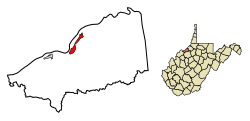
Location of St. Marys in Pleasants County, West Virginia.
Country United States
State West Virginia
County Pleasants
Area
 • Total 1.03 sq mi (2.66 km2)
 • Land 1.02 sq mi (2.65 km2)
 • Water 0.00 sq mi (0.01 km2)
Population (2010)
 • Estimate (2017) 1,787
For infobox source see[1]

Municipality Well Data

Well ID Operator Name Permit Date Spud Date Configuration License Status
47-073-00122 STEELE BROTHERS Vertical Completed
47-073-00461 BEARDMORE, CLARENCE E. Vertical Completed
47-073-00873 LAUDERMAN OIL & GAS DRILLING 1980-07-28 Vertical Completed
47-073-00893 BIG INJUN DRILLING CORP. 1980-08-06 Vertical Completed
47-073-00895 L & B OIL CO., INC. 1980-07-15 Vertical Completed
47-073-00909 CARBONIT EXPLORATION, INC. 1981-02-21 Vertical Completed
47-073-00911 L & B OIL CO., INC. 1980-07-23 Vertical Completed
47-073-00923 CARBONIT EXPLORATION, INC. 1980-08-16 Vertical Completed
47-073-00924 CARBONIT EXPLORATION, INC. 1980-08-28 Vertical Completed
47-073-00925 B. E. R. G. PETROLEUM CORP. 1980-08-26 Vertical Completed
47-073-00932 B. E. R. G. PETROLEUM CORP. 1980-09-04 Vertical Completed
47-073-00944 L & B OIL CO., INC. 1980-09-05 Vertical Completed
47-073-00985 OPERATOR UNKNOWN Never Drilled
47-073-01003 B. E. R. G. PETROLEUM CORP. 1981-02-20 Vertical Completed
47-073-01074 L & B OIL CO., INC. 1980-12-18 Vertical Completed
47-073-01084 RARE EARTH MINERALS, INC. 1981-09-23 Vertical Completed
47-073-01156 HAUGHT, INC. 1983-08-03 Vertical Completed
47-073-01157 HAUGHT, INC. 1981-04-30 Vertical Completed
47-073-02164 Vertical
47-073-02528 WVDEP OFFICE OF OIL & GAS 2010-11-15 2010-12-14 Vertical Completed
47-073-02591 PATCHWORK OIL & GAS, LLC 2019-02-04 Vertical Permitted
47-073-30180 OPER IN MIN.OWNER FLD,NO CODE ASSGN(ORPHAN WELL PROJ) Vertical Completed
47-073-30253 DINSMOOR & CO. Vertical Completed
47-073-30254 DINSMOOR & CO. Vertical Completed
47-073-30571 BEARDMORE, CLARENCE E. Vertical Completed
47-073-30572 BEARDMORE, CLARENCE E. Vertical Completed
47-073-30573 BEARDMORE, CLARENCE E. Vertical Completed
47-073-30574 BEARDMORE, CLARENCE E. Vertical Completed
47-073-90298 Vertical
47-073-90299 Vertical
47-073-90300 Vertical
47-073-90313 Vertical
47-073-90314 Vertical
47-073-90315 Vertical
47-073-90322 Vertical
47-073-90323 Vertical
47-073-90324 Vertical
47-073-90325 Vertical
47-073-90326 Vertical
47-073-90327 Vertical
47-073-90328 Vertical
47-073-90329 Vertical
47-073-90330 Vertical
47-073-90367 Vertical
47-073-90368 Vertical
47-073-90369 Vertical
47-073-90370 Vertical
47-073-90371 Vertical
47-073-90382 Vertical
47-073-90383 Vertical
47-073-90389 Vertical
47-073-90390 Vertical
47-073-90391 Vertical
47-073-90392 Vertical
47-073-90393 Vertical
47-073-90404 Vertical

For data sources see[2]

References

  1. "St. Marys, West Virginia". Wikipedia. Retrieved 2019-08-25. 
  2. "Risk Based Data Management System". Ohio Department of Natural Resources. 2019-05-07. Retrieved 2019-05-21.