Cessna Township, Hardin County, Ohio
| Center Township, Mercer County, Ohio | |
|---|---|
| Township | |
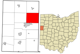
 Location in Mercer County and the state of Ohio. | |
| Country | United States |
| State | Ohio |
| County | Mercer |
| Area | |
| • Total | 30.3 sq mi (78.4 km2) |
| • Land | 30.3 sq mi (78.4 km2) |
| • Water | 0.0 sq mi (0.0 km2) |
| Elevation | 853 ft (260 m) |
| Population (2000) | |
| • Total | 1,082 |
| • Density | 35.7/sq mi (13.8/km2) |
| Time zone | Eastern (EST) (UTC-5) |
| • Summer (DST) | EDT (UTC-4) |
| For infobox source see[1] | |
Contents
Municipality Well Data
| Well ID | Operator Name | Permit Date | Spud Date | Configuration | License Status |
|---|---|---|---|---|---|
| 34-065-20049 | HISTORIC OWNER | 1951-11-01 | Vertical | Historical Production Well | |
| 34-065-20058 | HISTORIC OWNER | 1953-11-01 | Vertical | Plugged and Abandoned | |
| 34-065-20069 | KRITZLER WILBER R | 1996-08-12 | 1955-10-04 | Vertical | Final Restoration |
| 34-065-20106 | HISTORIC OWNER | 1965-08-27 | 1965-08-23 | Vertical | Plugged and Abandoned |
| 34-065-20108 | HISTORIC OWNER | 1966-12-22 | 1966-12-22 | Vertical | Plugged and Abandoned |
| 34-065-20124 | G-R-F ENERGY, INC | 1989-05-23 | 1983-08-15 | Vertical | Final Restoration |
| 34-065-20130 | JAMES R SMAIL INC | 1997-01-07 | Vertical | Final Restoration | |
| 34-065-20132 | NETHERS GARY L | 1996-10-22 | 1996-12-02 | Vertical | Final Restoration |
| 34-065-60048 | HISTORIC OWNER | 1900-01-01 | Vertical | Plugged and Abandoned | |
| 34-065-60050 | HISTORIC OWNER | 1900-01-01 | Vertical | Historical Production Well | |
| 34-065-60052 | HISTORIC OWNER | 1900-01-01 | Vertical | Historical Production Well | |
| 34-065-60053 | HISTORIC OWNER | 1900-01-01 | Vertical | Historical Production Well | |
| 34-065-60054 | HISTORIC OWNER | 1900-01-01 | Vertical | Historical Production Well | |
| 34-065-60055 | HISTORIC OWNER | 1900-01-01 | Vertical | Historical Production Well | |
| 34-065-60056 | HISTORIC OWNER | 1900-01-01 | Vertical | Historical Production Well | |
| 34-065-60057 | HISTORIC OWNER | 1900-01-01 | Vertical | Historical Production Well | |
| 34-065-60058 | HISTORIC OWNER | 1900-01-01 | Vertical | Historical Production Well | |
| 34-065-60059 | HISTORIC OWNER | 1900-01-01 | Vertical | Historical Production Well | |
| 34-065-60060 | HISTORIC OWNER | Vertical | Not Drilled | ||
| 34-065-60061 | HISTORIC OWNER | 1900-01-01 | Vertical | Plugged and Abandoned | |
| 34-065-60062 | HISTORIC OWNER | 1900-01-01 | Vertical | Plugged and Abandoned | |
| 34-065-60063 | HISTORIC OWNER | 1900-01-01 | Vertical | Historical Production Well |
For data sources see[2]
References
- ↑ "Center Township, Mercer County, Ohio#". Wikipedia. Retrieved 2021-01-11.
- ↑ "Risk Based Data Management System". Ohio Department of Natural Resources. 2020-11-16. Retrieved 2020-11-16.