Barberton, Ohio
| Barberton, Ohio | |
|---|---|
| City | |
| Nickname(s): The Magic City | |
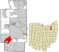
 Location in Summit County and the state of Ohio. | |
| Country | United States |
| State | Ohio |
| County | Summit |
| Area | |
| • Total | 9.24 sq mi (23.93 km2) |
| • Land | 9.02 sq mi (23.35 km2) |
| • Water | 0.22 sq mi (0.57 km2) |
| Elevation | 974 ft (297 m) |
| Population (2010) | |
| • Estimate (2019) | 25,953 |
| ZIP code | 44203 |
| Website | https://www.cityofbarberton.com/ |
| For infobox source see[1] | |
Contents
Municipality Well Data
| Well ID | Operator Name | Permit Date | Spud Date | Configuration | License Status |
|---|---|---|---|---|---|
| 34-153-20309 | HISTORIC OWNER | 1900-01-01 | Vertical | Plugged and Abandoned | |
| 34-153-20341 | HISTORIC OWNER | 1957-11-08 | Vertical | Plugged and Abandoned | |
| 34-153-20349 | PPG INDUSTRIES INC | 1983-11-23 | 1958-08-28 | Vertical | Final Restoration |
| 34-153-20399 | HISTORIC OWNER | 1928-11-15 | Vertical | Plugged and Abandoned | |
| 34-153-20400 | HISTORIC OWNER | 1964-01-03 | Vertical | Not Drilled | |
| 34-153-20406 | PPG INDUSTRIES INC | 1994-04-11 | 1965-01-19 | Vertical | Final Restoration |
| 34-153-21025 | MTM OIL CO | 2005-07-15 | 1981-10-30 | Vertical | Final Restoration |
| 34-153-21048 | MTM OIL CO | 2005-07-26 | Vertical | Final Restoration | |
| 34-153-21297 | MORGAN PENNINGTON INC | 1982-12-03 | 1983-04-05 | Vertical | Final Restoration |
| 34-153-21850 | PPG INDUSTRIES INC | 1984-05-21 | Vertical | Final Restoration | |
| 34-153-21856 | PPG INDUSTRIES INC | 1994-02-24 | Vertical | Final Restoration | |
| 34-153-21861 | PPG INDUSTRIES INC | 1984-12-21 | Vertical | Final Restoration | |
| 34-153-21935 | DIVERSIFIED PRODUCTION LLC | 1987-06-17 | 1987-07-19 | Vertical | Producing |
| 34-153-22017 | ENTERPRISE ENERGY CORP | 1984-12-27 | Vertical | Not Drilled | |
| 34-153-22074 | ENERVEST OPERATING LLC | 2012-09-17 | 1987-11-06 | Vertical | Final Restoration |
| 34-153-22181 | RANGE OPERATING COMPANY | 1997-12-23 | 1989-12-09 | Vertical | Final Restoration |
| 34-153-22191 | ENERVEST OPERATING LLC | 2012-09-17 | 1987-12-02 | Vertical | Plugged and Abandoned |
| 34-153-22356 | MS PRODUCING LLC | 1987-03-06 | 1987-03-08 | Vertical | Producing |
| 34-153-22362 | MS PRODUCING LLC | 1987-05-04 | 1987-05-11 | Vertical | Producing |
| 34-153-22376 | BROAD STREET ENERGY COMPANY | 2006-01-31 | 1987-07-14 | Vertical | Final Restoration |
| 34-153-22398 | JD PRODUCING INC | 1998-10-26 | 1987-11-15 | Vertical | Final Restoration |
| 34-153-22399 | H & H PRODUCING | 1987-09-03 | Vertical | Not Drilled | |
| 34-153-22412 | ENVIRONMENTAL EXP CO | 1988-01-27 | 1988-02-29 | Vertical | Producing |
| 34-153-22443 | STMX GAS INC DBA AUTUMN RIDGE | 2012-07-13 | 1989-02-17 | Vertical | Producing |
| 34-153-22456 | APPALACHIAN EXPL INC | 1988-12-16 | Vertical | Not Drilled | |
| 34-153-22457 | APPALACHIAN EXPL INC | 1988-12-16 | Vertical | Not Drilled | |
| 34-153-22459 | SCHREINER OIL & GAS INC | 1988-08-25 | 1988-08-26 | Vertical | Plugged and Abandoned |
| 34-153-22570 | SCHREINER OIL & GAS INC | 2005-06-02 | 1989-02-07 | Directional | Plugged and Abandoned |
| 34-153-22580 | STMX GAS INC DBA AUTUMN RIDGE | 1989-06-19 | 1989-07-11 | Vertical | Producing |
| 34-153-22585 | SCHREINER OIL & GAS INC | 2015-10-08 | 1989-08-23 | Vertical | Producing |
| 34-153-22586 | SCHREINER OIL & GAS INC | 2005-06-02 | 1989-08-29 | Vertical | Plugged and Abandoned |
| 34-153-22595 | APPALACHIAN EXPL INC | 1989-08-22 | Vertical | Not Drilled | |
| 34-153-22596 | SCHREINER OIL & GAS INC | 2005-06-02 | 1990-03-11 | Vertical | Plugged and Abandoned |
| 34-153-22606 | BARBERTON BOARD OF ED. | 1996-04-11 | 1989-10-21 | Vertical | Final Restoration |
| 34-153-22641 | SCHREINER OIL & GAS INC | 2007-09-06 | 1990-03-04 | Vertical | Plugged and Abandoned |
| 34-153-22740 | SCHREINER OIL & GAS INC | 2005-06-02 | 1992-02-03 | Vertical | Plugged and Abandoned |
| 34-153-22791 | PPG INDUSTRIES INC | 1994-08-10 | 1994-09-01 | Vertical | Final Restoration |
| 34-153-22959 | WESCOR LLC | 2005-10-25 | 2006-08-10 | Vertical | Producing |
| 34-153-22969 | SCHREINER OIL & GAS INC | 2006-12-22 | 2006-08-30 | Vertical | Lost Hole |
| 34-153-22990 | M & M ROYALTY LTD | 2006-12-20 | 2007-01-15 | Vertical | Final Restoration |
| 34-153-60059 | HISTORIC OWNER | Vertical | Not Drilled | ||
| 34-153-60060 | HISTORIC OWNER | Vertical | Plugged and Abandoned | ||
| 34-153-60340 | HISTORIC OWNER | 1900-01-01 | Vertical | Plugged and Abandoned | |
| 34-153-60342 | HISTORIC OWNER | Vertical | Plugged and Abandoned | ||
| 34-153-60344 | HISTORIC OWNER | 1900-01-01 | Vertical | Historical Production Well |
For data sources see[2]
References
- ↑ "Barberton, Ohio#". Wikipedia. Retrieved 2021-01-11.
- ↑ "Risk Based Data Management System". Ohio Department of Natural Resources. 2020-11-16. Retrieved 2020-11-16.