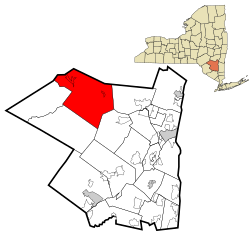
Shandaken, Ulster County, New York
| Shandaken, New York | |
|---|---|
| Town | |
|
US Census Map US Census Map | |
 Location in Ulster County and the state of New York. | |
| Country | United States |
| State | New York |
| County | Ulster |
| Area | |
| • Total | 119.84 sq mi (310.39 km2) |
| • Land | 119.78 sq mi (310.24 km2) |
| • Water | 0.06 sq mi (0.15 km2) |
| Elevation | 1,348 ft (411 m) |
| Population (2010) | |
| • Total | 3,085 |
| • Density | 24.88/sq mi (9.61/km2) |
| Time zone | Eastern (EST) (UTC-5) |
| • Summer (DST) | EDT (UTC-4) |
| ZIP code | 12480 |
| Area code(s) | 845 |
| For infobox source see[1] | |
Contents
Municipality Well Data
| Well ID | Operator Name | Permit Date | Spud Date | Configuration | Well Status |
|---|---|---|---|---|---|
| 31-111-02656 | Unknown | Vertical | Plugged And Abandoned | ||
| 31-111-02657 | Unknown | Vertical | Plugged And Abandoned | ||
| 31-111-02658 | Unknown | Vertical | Plugged And Abandoned | ||
| 31-111-03199 | Dome Oil & Gas | 1954-03-17 | Vertical | Plugged And Abandoned |
For data sources see[2]
References
- ↑ "Shandaken, New York". Wikipedia. Retrieved 2021-07-19.
- ↑ "Public Wells Data". New York State Department of Environmental Conservation. 2019-08-09. Retrieved 2019-08-09.