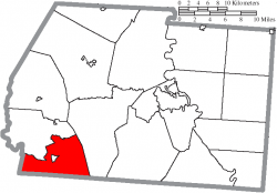
Perry Township, Lawrence County, Ohio
| Paxton Township, Ross County, Ohio | |
|---|---|
| Township | |
 Location of Paxton Township in Ross County | |
| Country | United States |
| State | Ohio |
| County | Ross |
| Area | |
| • Total | 31.8 sq mi (82.4 km2) |
| • Land | 31.7 sq mi (82.2 km2) |
| • Water | 0.1 sq mi (0.2 km2) |
| Elevation | 810 ft (247 m) |
| Population (2000) | |
| • Total | 2,165 |
| • Density | 68.2/sq mi (26.3/km2) |
| Time zone | Eastern (EST) (UTC-5) |
| • Summer (DST) | EDT (UTC-4) |
| For infobox source see[1] | |
Contents
Municipality Well Data
| Well ID | Operator Name | Permit Date | Spud Date | Configuration | License Status |
|---|---|---|---|---|---|
| 34-087-20253 | EASTERN AMER ENERGY CORP | 1992-10-15 | 1979-04-02 | Vertical | Final Restoration |
| 34-087-20258 | PETRO QUEST INC | 1978-09-29 | 1978-10-02 | Vertical | Producing |
| 34-087-20275 | CHESAPEAKE APPALACHIA LLC | 2011-12-05 | 1980-11-12 | Vertical | Final Restoration |
| 34-087-20286 | SMITH RONALD DBA CHIPCO | 2010-07-12 | 1981-11-28 | Vertical | Final Restoration |
| 34-087-20287 | HISTORIC OWNER | 1981-03-19 | 1981-12-29 | Vertical | Plugged and Abandoned |
| 34-087-20291 | PEMBERTON DEBRA | 1981-09-25 | 1981-12-07 | Vertical | Domestic Well |
| 34-087-20292 | PETRO QUEST INC | 1982-02-24 | 1982-05-20 | Vertical | Producing |
| 34-087-20295 | SMITH RONALD DBA CHIPCO | 2010-07-14 | 1982-09-18 | Vertical | Final Restoration |
| 34-087-20297 | EQUITY OIL & GAS FUNDS INC | 2014-04-21 | 1982-01-08 | Vertical | Plugged and Abandoned |
| 34-087-20300 | CHESAPEAKE APPALACHIA LLC | 1992-05-27 | 1982-09-02 | Vertical | Final Restoration |
| 34-087-20301 | DORAN & ASSOCIATES | 1982-07-09 | Vertical | Not Drilled | |
| 34-087-20302 | PETRO QUEST INC | 1982-07-09 | 1982-09-22 | Vertical | Producing |
| 34-087-20309 | SMITH RONALD DBA CHIPCO | 2010-07-14 | 1981-12-14 | Vertical | Final Restoration |
| 34-087-20325 | EQUITY OIL & GAS FUNDS INC | 1982-02-08 | 1982-07-01 | Vertical | Producing |
| 34-087-20326 | DORAN & ASSOCIATES | 1982-08-25 | Vertical | Not Drilled | |
| 34-087-20327 | DORAN & ASSOCIATES | 1982-02-08 | Vertical | Not Drilled | |
| 34-087-20328 | DORAN & ASSOCIATES | 1982-02-08 | Vertical | Not Drilled | |
| 34-087-20655 | NYTIS EXPLORATION CO LLC | 2007-11-30 | 2007-12-13 | Directional | Producing |
| 34-087-60030 | HISTORIC OWNER | 1900-01-01 | Vertical | Plugged and Abandoned | |
| 34-087-60031 | HISTORIC OWNER | Vertical | Historical Production Well | ||
| 34-087-60032 | HISTORIC OWNER | 1900-01-01 | Vertical | Historical Production Well | |
| 34-087-60034 | HISTORIC OWNER | 1986-06-10 | Vertical | Plugged and Abandoned | |
| 34-087-60035 | HISTORIC OWNER | 1986-06-10 | 1900-01-01 | Vertical | Plugged and Abandoned |
| 34-087-60036 | HISTORIC OWNER | 1900-01-01 | Vertical | Plugged and Abandoned | |
| 34-087-60037 | HISTORIC OWNER | Vertical | Plugged and Abandoned | ||
| 34-087-60038 | HISTORIC OWNER | 1917-04-30 | Vertical | Plugged and Abandoned | |
| 34-087-60039 | HISTORIC OWNER | 1917-01-01 | Vertical | Plugged and Abandoned | |
| 34-087-60040 | HISTORIC OWNER | Vertical | Plugged and Abandoned | ||
| 34-087-60041 | HISTORIC OWNER | 1900-01-01 | Vertical | Historical Production Well | |
| 34-087-60042 | HISTORIC OWNER | Vertical | Plugged and Abandoned | ||
| 34-087-60043 | HISTORIC OWNER | 1930-03-01 | Vertical | Plugged and Abandoned | |
| 34-087-60044 | HISTORIC OWNER | 1930-06-10 | Vertical | Plugged and Abandoned | |
| 34-087-60045 | HISTORIC OWNER | 1900-01-01 | Vertical | Plugged and Abandoned | |
| 34-087-60046 | HISTORIC OWNER | 1986-06-10 | Vertical | Plugged and Abandoned | |
| 34-087-60047 | HISTORIC OWNER | Vertical | Plugged and Abandoned | ||
| 34-087-60152 | HISTORIC OWNER | 1900-01-01 | Vertical | Plugged and Abandoned | |
| 34-087-60164 | HISTORIC OWNER | 1900-01-01 | Vertical | Field Inspected: Well Not Found | |
| 34-087-60180 | HISTORIC OWNER | 1930-02-07 | Vertical | Plugged and Abandoned |
For data sources see[2]
References
- ↑ "Paxton Township, Ross County, Ohio#". Wikipedia. Retrieved 2021-01-12.
- ↑ "Risk Based Data Management System". Ohio Department of Natural Resources. 2020-11-16. Retrieved 2020-11-16.