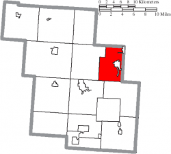
Henrietta Township, Lorain County, Ohio
| Harrison Township, Perry County, Ohio | |
|---|---|
| Township | |
 Location of Harrison Township in Perry County | |
| Country | United States |
| State | Ohio |
| County | Perry |
| Area | |
| • Total | 23.3 sq mi (60.3 km2) |
| • Land | 23.2 sq mi (60.2 km2) |
| • Water | 0.1 sq mi (0.2 km2) |
| Elevation | 778 ft (237 m) |
| Population (2000) | |
| • Total | 5,399 |
| • Density | 232.4/sq mi (89.7/km2) |
| Time zone | Eastern (EST) (UTC-5) |
| • Summer (DST) | EDT (UTC-4) |
| For infobox source see[1] | |
Contents
Municipality Well Data
| Well ID | Operator Name | Permit Date | Spud Date | Configuration | License Status |
|---|---|---|---|---|---|
| 34-043-20015 | FRANKLIN GAS & OIL CO LLC | 1966-08-17 | 1966-08-22 | Vertical | Active Injection |
| 34-043-20030 | FRANKLIN GAS & OIL CO LLC | 1967-05-09 | 1967-06-25 | Vertical | Producing |
| 34-043-20036 | ERIE OIL & GAS CO | 1984-08-16 | 1972-12-05 | Vertical | Final Restoration |
| 34-043-20037 | CASSIDY SAM H SR | 1972-11-24 | Vertical | Not Drilled | |
| 34-043-20060 | FRANKLIN GAS & OIL CO LLC | 1973-11-26 | 1974-02-17 | Vertical | Producing |
| 34-043-20063 | FRANKLIN GAS & OIL CO LLC | 1974-04-18 | 1974-05-09 | Vertical | Active Injection |
| 34-043-20075 | ZENITH EXPL CO INC | 1977-12-02 | 1978-02-15 | Vertical | Final Restoration |
| 34-093-20374 | HISTORIC OWNER | Vertical | Plugged and Abandoned | ||
| 34-093-20685 | HISTORIC OWNER | Vertical | Plugged and Abandoned | ||
| 34-093-20794 | POTTSY GEOPHYSICAL INC | 1985-10-16 | 1960-06-15 | Vertical | Dry and Abandoned |
| 34-093-20874 | KENDEIGH ALLEN AND DOLORES | 1966-03-23 | 1966-04-08 | Vertical | Domestic Well |
| 34-093-20890 | HARRISON WELL ENTERPRISES LTD | 2001-10-19 | 1966-09-14 | Vertical | Final Restoration |
| 34-093-20892 | HISTORIC OWNER | 1966-11-17 | 1966-12-13 | Vertical | Plugged and Abandoned |
| 34-093-20897 | GEOPETRO LLC | 2001-11-27 | 1967-02-21 | Vertical | Final Restoration |
| 34-093-20902 | HISTORIC OWNER | 1967-03-30 | 1967-05-22 | Vertical | Historical Production Well |
| 34-093-20908 | HISTORIC OWNER | 1967-07-06 | 1967-07-08 | Vertical | Plugged and Abandoned |
| 34-093-21003 | WELLS GENE & ANNE MARGARET | 1970-05-05 | 1970-06-05 | Vertical | Domestic Well |
| 34-093-21019 | HISTORIC OWNER | 1973-01-10 | 1973-01-22 | Vertical | Historical Production Well |
| 34-093-21028 | HISTORIC OWNER | 1974-01-16 | 1974-01-16 | Vertical | Historical Production Well |
| 34-093-21035 | HISTORIC OWNER | 1975-07-09 | Vertical | Not Drilled | |
| 34-093-21037 | STOYKA RONALD A | 1975-03-04 | 1975-03-17 | Vertical | Domestic Well |
| 34-093-21056 | ERIE OIL & GAS CO | 1992-06-23 | 1977-05-01 | Vertical | Final Restoration |
| 34-093-21058 | HISTORIC OWNER | 1977-05-18 | 1977-07-28 | Vertical | Historical Production Well |
| 34-093-21070 | HISTORIC OWNER | 1978-06-01 | Vertical | Not Drilled | |
| 34-093-21191 | CLARK JEFFREY J SANDRA | 1982-11-29 | 1900-01-01 | Vertical | Domestic Well |
| 34-093-21290 | POTTSY GEOPHYSICAL INC | 1985-08-30 | Vertical | Not Drilled | |
| 34-093-21291 | POTTSY GEOPHYSICAL INC | 1985-09-25 | Vertical | Not Drilled | |
| 34-093-21292 | POTTSY GEOPHYSICAL INC | 1985-09-25 | Vertical | Not Drilled | |
| 34-093-21293 | POTTSY GEOPHYSICAL INC | 1985-09-25 | Vertical | Not Drilled | |
| 34-093-21294 | POTTSY GEOPHYSICAL INC | 1985-09-25 | Vertical | Not Drilled | |
| 34-093-21295 | POTTSY GEOPHYSICAL INC | 1985-09-25 | Vertical | Not Drilled | |
| 34-093-21296 | POTTSY GEOPHYSICAL INC | 1985-09-25 | Vertical | Not Drilled | |
| 34-093-21297 | POTTSY GEOPHYSICAL INC | 1985-09-25 | Vertical | Not Drilled | |
| 34-093-21298 | POTTSY GEOPHYSICAL INC | 1985-09-25 | Vertical | Not Drilled | |
| 34-093-21304 | LANDOWNER GRANT PROGRAM 2004 | 2003-12-18 | 1986-01-14 | Vertical | Final Restoration |
| 34-093-21306 | BUCHS BERNARD | 1985-11-22 | 1985-11-04 | Vertical | Domestic Well |
| 34-093-21358 | MICHIGAN GEOSEARCH INC | 1990-06-12 | 1990-06-28 | Vertical | Final Restoration |
| 34-093-21395 | ROGERS GARY BRYCE | 1995-03-21 | Vertical | Final Restoration | |
| 34-093-21402 | VANOVER RONNIE MR & MRS | 1996-01-18 | Vertical | Final Restoration | |
| 34-093-21476 | FRANKLIN GAS & OIL CO LLC | 1999-05-10 | 1999-06-16 | Vertical | Dry and Abandoned |
| 34-093-21489 | ANGERSBACH ROLLAND F | 2000-07-19 | Vertical | Plugged and Abandoned | |
| 34-093-21520 | DOUZOS LOUIS A | 2003-11-13 | 2004-05-01 | Vertical | Domestic Well |
| 34-093-60355 | HISTORIC OWNER | 1949-11-07 | Vertical | Historical Production Well | |
| 34-093-60356 | CUNNINGHAM TROY | 1996-12-10 | 1900-01-01 | Vertical | Domestic Well |
| 34-093-60505 | HISTORIC OWNER | 1900-01-01 | Vertical | Final Restoration | |
| 34-093-60507 | COZMA VALER | 1900-01-01 | Vertical | Domestic Well | |
| 34-093-60515 | HISTORIC OWNER | 1900-01-01 | Vertical | Historical Production Well | |
| 34-093-60520 | HISTORIC OWNER | 1900-01-01 | Vertical | Orphan Well - Pending | |
| 34-093-60675 | HISTORIC OWNER | 1900-01-01 | Historical Production Well | ||
| 34-093-60680 | HISTORIC OWNER | 1900-01-01 | Historical Production Well |
For data sources see[2]
References
- ↑ "Harrison Township, Perry County, Ohio#". Wikipedia. Retrieved 2021-01-12.
- ↑ "Risk Based Data Management System". Ohio Department of Natural Resources. 2020-11-16. Retrieved 2020-11-16.