Difference between revisions of "Lock Haven City, Pennsylvania"
m |
m |
||
| Line 24: | Line 24: | ||
|area_total_sq_mi = 2.67 | |area_total_sq_mi = 2.67 | ||
|area_land_sq_mi = 2.50 | |area_land_sq_mi = 2.50 | ||
| − | |area_water_sq_mi = 0. | + | |area_water_sq_mi = 0.17 |
| + | |population_density_sq_mi = 3719.55 | ||
| + | | footnotes = For infobox source see<ref>{{cite web | ||
| title = Lock Haven, Pennsylvania | | title = Lock Haven, Pennsylvania | ||
| publisher = Wikipedia | | publisher = Wikipedia | ||
| url = https://en.wikipedia.org/wiki/Lock_Haven,_Pennsylvania | | url = https://en.wikipedia.org/wiki/Lock_Haven,_Pennsylvania | ||
| − | | accessdate = 2020-01- | + | | accessdate = 2020-01-15}}</ref> |
}}__TOC__ | }}__TOC__ | ||
== Municipality Well Data == | == Municipality Well Data == | ||
Latest revision as of 00:55, 16 January 2020
| Lock Haven, Pennsylvania | |
|---|---|
| City | |
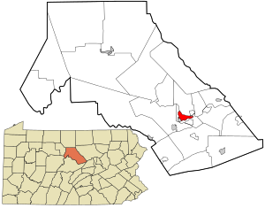
 Location within Clinton County | |
| Area | |
| • Total | 6.9 km2 (2.67 sq mi) |
| • Land | 6.5 km2 (2.50 sq mi) |
| • Water | 0.4 km2 (0.17 sq mi) |
| Elevation | 171 m (561 ft) |
| Population (2010) | |
| • Total | 9,772 |
| • Estimate (2018) | 9,108 |
| • Density | 1,436.13/km2 (3,719.55/sq mi) |
| For infobox source see[1] | |
Contents
Municipality Well Data
| Well ID | Operator Name | Permit Date | Spud Date | Unconventional | Configuration | License Status |
|---|---|---|---|---|---|---|
| 37-035-99999 | UNKNOWN OPR | 1800-01-01 | N | Vertical Well | Abandoned |
References
- ↑ "Lock Haven, Pennsylvania". Wikipedia. Retrieved 2020-01-15.
- ↑ "Permits Issued Detail Report". Pennsylvania Department of Environmental Protection. 2019-05-20. Retrieved 2019-05-21.
- ↑ "Spud Data Report". Pennsylvania Department of Environmental Protection. 2019-04-30. Retrieved 2019-05-16.
- ↑ "Oil and Gas Well Pad Report". Pennsylvania Department of Environmental Protection. 2019-05-20. Retrieved 2019-05-21.