Difference between revisions of "Brown Township, Lycoming County, Pennsylvania"
m |
m |
||
| Line 90: | Line 90: | ||
| publisher = Wikipedia | | publisher = Wikipedia | ||
| url = https://en.wikipedia.org/wiki/Brown_Township,_Lycoming_County,_Pennsylvania | | url = https://en.wikipedia.org/wiki/Brown_Township,_Lycoming_County,_Pennsylvania | ||
| − | | accessdate = 2019-07- | + | | accessdate = 2019-07-25}}</ref> |
}}__TOC__ | }}__TOC__ | ||
== Municipality Well Data == | == Municipality Well Data == | ||
| Line 104: | Line 104: | ||
| [[37-081-20001]] | | [[37-081-20001]] | ||
| [[FELMONT OIL CORP]] | | [[FELMONT OIL CORP]] | ||
| − | | | + | | 1961-04-05 |
| − | | 01 | + | | 1800-01-01 |
| N | | N | ||
| Vertical Well | | Vertical Well | ||
| Line 112: | Line 112: | ||
| [[37-081-20004]] | | [[37-081-20004]] | ||
| [[DOMINION ENERGY TRANS INC]] | | [[DOMINION ENERGY TRANS INC]] | ||
| − | | 12 | + | | 1961-12-27 |
| − | | 01 | + | | 1962-01-10 |
| N | | N | ||
| Vertical Well | | Vertical Well | ||
| Line 120: | Line 120: | ||
| [[37-081-20028]] | | [[37-081-20028]] | ||
| [[PENNZOIL PROD CO]] | | [[PENNZOIL PROD CO]] | ||
| − | | | + | | 1984-06-07 |
| − | | 08 | + | | 1984-08-28 |
| N | | N | ||
| Vertical Well | | Vertical Well | ||
| Line 129: | Line 129: | ||
| [[UNKNOWN OPR]] | | [[UNKNOWN OPR]] | ||
| | | | ||
| − | | 01 | + | | 1800-01-01 |
| N | | N | ||
| Vertical Well | | Vertical Well | ||
Revision as of 18:07, 25 July 2019
| Brown Township, Lycoming County, Pennsylvania | |
|---|---|
| Township | |
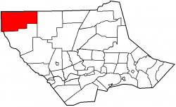
 Map of Lycoming County, Pennsylvania highlighting Brown Township | |
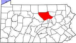
 Map of Lycoming County, Pennsylvania | |
| Country | United States |
| State | Pennsylvania |
| County | Lycoming |
| Settled | 1794 |
| Formed | 1815 |
| Area | |
| • Total | 74.03 sq mi (191.74 km2) |
| • Land | 73.34 sq mi (189.96 km2) |
| • Water | 0.69 sq mi (1.78 km2) |
| Elevation | 1,988 ft (606 m) |
| Population (2010) | |
| • Total | 96 |
| • Density | 1.30/sq mi (0.50/km2) |
| Time zone | Eastern Time Zone (North America) (UTC-5) |
| • Summer (DST) | EDT (UTC-4) |
| For infobox source see[1] | |
Contents
Municipality Well Data
| Well ID | Operator Name | Permit Date | Spud Date | Unconventional | Configuration | License Status |
|---|---|---|---|---|---|---|
| 37-081-20001 | FELMONT OIL CORP | 1961-04-05 | 1800-01-01 | N | Vertical Well | Plugged OG Well |
| 37-081-20004 | DOMINION ENERGY TRANS INC | 1961-12-27 | 1962-01-10 | N | Vertical Well | Plugged OG Well |
| 37-081-20028 | PENNZOIL PROD CO | 1984-06-07 | 1984-08-28 | N | Vertical Well | Plugged OG Well |
| 37-081-90005 | UNKNOWN OPR | 1800-01-01 | N | Vertical Well | Abandoned |
References
- ↑ "Brown Township, Lycoming County, Pennsylvania". Wikipedia. Retrieved 2019-07-25.
- ↑ "Permits Issued Detail Report". Pennsylvania Department of Environmental Protection. 2019-05-20. Retrieved 2019-05-21.
- ↑ "Spud Data Report". Pennsylvania Department of Environmental Protection. 2019-04-30. Retrieved 2019-05-16.
- ↑ "Oil and Gas Well Pad Report". Pennsylvania Department of Environmental Protection. 2019-05-20. Retrieved 2019-05-21.