Difference between revisions of "Beaver Borough, Beaver County, Pennsylvania"
m |
m |
||
| Line 1: | Line 1: | ||
| + | {{Infobox settlement | ||
| + | |official_name = Beaver, Pennsylvania | ||
| + | |other_name = | ||
| + | |native_name = | ||
| + | |nickname = | ||
| + | |settlement_type =Borough | ||
| + | |motto = | ||
| + | <!-- images and maps -----------> | ||
| + | |image_skyline = Downtown Beaver Pennsylvania.jpg | ||
| + | |imagesize = | ||
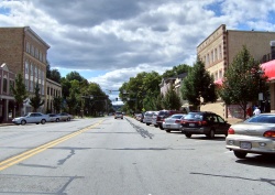
| + | |image_caption = Along Third Street in downtown Beaver | ||
| + | |image_flag = | ||
| + | |flag_size = | ||
| + | |image_seal = | ||
| + | |seal_size = | ||
| + | |image_shield = | ||
| + | |shield_size = | ||
| + | |image_blank_emblem = | ||
| + | |blank_emblem_size = | ||
| + | |image_map = Map of Beaver, Beaver County, Pennsylvania Highlighted.png | ||
| + | |mapsize = 250px | ||
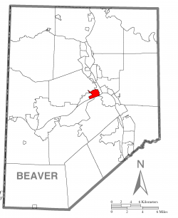
| + | |map_caption = Location in Beaver County | ||
| + | |image_map1 = Map of Pennsylvania highlighting Beaver County.svg | ||
| + | |mapsize1 = 250px | ||
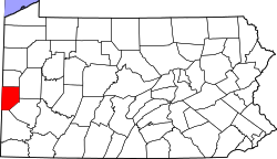
| + | |map_caption1 = Location in the state of Pennsylvania | ||
| + | <!-- Location ------------------> | ||
| + | |coordinates_region = US-PA | ||
| + | |subdivision_type = [[wikipedia:List of countries|Country]] | ||
| + | |subdivision_name = [[wikipedia:United States|United States]] | ||
| + | |subdivision_type1 = [[wikipedia:Political divisions of the United States|State]] | ||
| + | |subdivision_name1 = [[wikipedia:Pennsylvania|Pennsylvania]] | ||
| + | |subdivision_type2 = [[wikipedia:List of counties in Pennsylvania|County]] | ||
| + | |subdivision_name2 = [[wikipedia:Beaver County, Pennsylvania|Beaver]] | ||
| + | |government_footnotes = | ||
| + | |government_type = Borough Council | ||
| + | |leader_title = Mayor | ||
| + | |leader_name = | ||
| + | |leader_title1 = | ||
| + | |leader_name1 = | ||
| + | |leader_title2 = | ||
| + | |leader_name2 = | ||
| + | |leader_title3 = | ||
| + | |leader_name3 = | ||
| + | |leader_title4 = | ||
| + | |leader_name4 = | ||
| + | |established_title = Settled | ||
| + | |established_date = 1792 | ||
| + | |established_title1 = Incorporated | ||
| + | |established_date1 = 1802 | ||
| + | |area_magnitude = | ||
| + | |unit_pref = | ||
| + | |unit_pref = Imperial | ||
| + | |area_footnotes = | ||
| + | |area_total_km2 = | ||
| + | |area_land_km2 = | ||
| + | |area_water_km2 = | ||
| + | |area_total_sq_mi = 1.1 | ||
| + | |area_land_sq_mi = 0.9 | ||
| + | |area_water_sq_mi = 0.2 | ||
| + | |area_water_percent = | ||
| + | |population_as_of = 2010 | ||
| + | |population_footnotes = | ||
| + | |population_note = | ||
| + | |population_total = 4531 | ||
| + | |population_density_km2 = | ||
| + | |population_density_sq_mi = 5119.3 | ||
| + | |timezone = [[wikipedia:North American Eastern Time Zone|Eastern (EST)]] | ||
| + | |utc_offset = -5 | ||
| + | |timezone_DST = EDT | ||
| + | |utc_offset_DST = -4 | ||
| + | |coordinates_display = inline,title | ||
| + | |coordinates_type = region:US_type:city | ||
| + | |latd = 40 | ||
| + | |latm = 41 | ||
| + | |lats = 41 | ||
| + | |latNS = N | ||
| + | |longd = 80 | ||
| + | |longm = 18 | ||
| + | |longs = 27 | ||
| + | |longEW = W | ||
| + | |elevation_footnotes = | ||
| + | |elevation_m = | ||
| + | |elevation_ft = 791 | ||
| + | |postal_code_type = [[wikipedia:Zip code|Zip code]] | ||
| + | |postal_code = 15009 | ||
| + | |area_code = [[wikipedia:Area code 724|724]] | ||
| + | |website = http://www.beaverpa.us | ||
| + | |footnotes = | ||
| + | {{Infobox NRHP | ||
| + | | name = Beaver Historic District | ||
| + | | embed = yes | ||
| + | | nrhp_type = hd | ||
| + | | nocat = yes | ||
| + | | image = First Christian Church, Beaver.jpg | ||
| + | | caption = First Christian Church, a part of the district | ||
| + | | location= Roughly bounded by the [[wikipedia:Cumberland and Pennsylvania Railroad|Cumberland and Pennsylvania Railroad]] tracks, Fair Ave., 5th St., 3rd St., and Sassafras Ln. | ||
| + | | district_map = Beaver Historic District map.png | ||
| + | | map_caption = Map of the Beaver Historic District | ||
| + | | area = {{convert|317|acre}} | ||
| + | | built = 1792 | ||
| + | | architect = multiple | ||
| + | | architecture = Italianate, Queen Anne, American Foursquare | ||
| + | | added = October 24, 1996 | ||
| + | | governing_body = Federal | ||
| + | | refnum = 96001201<ref name=nris>{{NRISref|2009a}}</ref> | ||
| + | | designated_other1_name = Pennsylvania state historical marker | ||
| + | | designated_other1_abbr=PHMC | ||
| + | | designated_other1_date = September 25, 1946<ref name=phmcdatabase>{{cite web | title = PHMC Historical Markers | work =Historical Marker Database | publisher = | date =Pennsylvania Historical & Museum Commission | url =http://search.pahistoricalmarkers.com/ | accessdate = December 10, 2013}}</ref> | ||
| + | | designated_other1_link = List of Pennsylvania state historical markers | ||
| + | | designated_other1_color = navy | ||
| + | | designated_other1_textcolor=#ffc94b | ||
| + | }}}} | ||
== Municipality Details == | == Municipality Details == | ||
__TOC__ | __TOC__ | ||
Revision as of 20:37, 12 April 2014
| Beaver, Pennsylvania | |
|---|---|
| Borough | |
 Along Third Street in downtown Beaver | |
 Location in Beaver County | |
 Location in the state of Pennsylvania | |
|
Coordinates: 40°41′41″N 80°18′27″W / 40.69472°N 80.30750°WCoordinates: 40°41′41″N 80°18′27″W / 40.69472°N 80.30750°W Fatal error: The format of the coordinate could not be determined. Parsing failed. | |
| Country | United States |
| State | Pennsylvania |
| County | Beaver |
| Settled | 1792 |
| Incorporated | 1802 |
| Government | |
| • Type | Borough Council |
| Area | |
| • Total | 1.1 sq mi (3 km2) |
| • Land | 0.9 sq mi (2 km2) |
| • Water | 0.2 sq mi (0.5 km2) |
| Elevation | 791 ft (241 m) |
| Population (2010) | |
| • Total | 4,531 |
| • Density | 5,119.3/sq mi (1,976.6/km2) |
| Time zone | Eastern (EST) (UTC-5) |
| • Summer (DST) | EDT (UTC-4) |
| Zip code | 15009 |
| Area code(s) | 724 |
| Website | http://www.beaverpa.us |
| Template:Infobox NRHP | |