Difference between revisions of "Southgate, Grey, Ontario"
m |
m |
||
| (One intermediate revision by the same user not shown) | |||
| Line 3: | Line 3: | ||
|official_name = Township of Southgate | |official_name = Township of Southgate | ||
|settlement_type = [[wikipedia:List of township municipalities in Ontario|Township]] ([[wikipedia:List of municipalities in Ontario#Lower-tier municipalities|lower-tier]]) | |settlement_type = [[wikipedia:List of township municipalities in Ontario|Township]] ([[wikipedia:List of municipalities in Ontario#Lower-tier municipalities|lower-tier]]) | ||
| + | |coordinates = {{coord|44|06|N|80|35|W|region:CA-ON|display=inline,title}} | ||
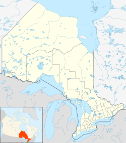
| + | | image_map = {{Location map | Ontario municipal districts | ||
| + | | width = 250 | ||
| + | | lat_deg = 44 | lat_min = 06 | lat_sec = 0 | lat_dir = N | ||
| + | | lon_deg = 80 | lon_min = 35 | lon_sec = 0 | lon_dir = W | ||
| + | | label = Southgate}} | ||
| + | |subdivision_type = [[wikipedia:Countries of the world|Country]] | ||
|subdivision_name = [[wikipedia:Canada|Canada]] | |subdivision_name = [[wikipedia:Canada|Canada]] | ||
|subdivision_type1 = [[wikipedia:Provinces and territories of Canada|Province]] | |subdivision_type1 = [[wikipedia:Provinces and territories of Canada|Province]] | ||
| Line 11: | Line 18: | ||
| established_date = | | established_date = | ||
| established_title2 = Formed | | established_title2 = Formed | ||
| − | | established_date2 = January 1, 2000| footnotes = For infobox source see<ref>{{cite web | + | | established_date2 = January 1, 2000 |
| + | | area_total_km2 = | ||
| + | | area_land_km2 = 644.38 | ||
| + | | area_water_km2 = | ||
| + | | area_footnotes = | ||
| + | | population_as_of = 2016 | ||
| + | | population_footnotes = | ||
| + | | population_total = 7190 | ||
| + | | population_density_km2=11.4 | ||
| + | | timezone = [[wikipedia:Eastern Time Zone|EST]] | ||
| + | | utc_offset = -5 | ||
| + | | timezone_DST = [[wikipedia:Eastern Time Zone|EDT]] | ||
| + | | utc_offset_DST = -4 | ||
| + | | postal_code_type = [[wikipedia:Canadian postal code|Postal Code]] | ||
| + | | postal_code = N0C 1B0 | ||
| + | | area_code = [[wikipedia:Area codes 519 and 226|519 and 226]] | ||
| + | | elevation_footnotes = | ||
| + | | elevation_m = | ||
| + | | website = [http://www.southgate.ca/ www.southgate.ca] | ||
| + | | footnotes = For infobox source see<ref>{{cite web | ||
| title = Southgate, Ontario | | title = Southgate, Ontario | ||
| publisher = Wikipedia | | publisher = Wikipedia | ||
| url = https://en.wikipedia.org/wiki/Southgate,_Ontario | | url = https://en.wikipedia.org/wiki/Southgate,_Ontario | ||
| − | | accessdate = 2020- | + | | accessdate = 2020-09-15}}</ref> |
}}__TOC__ | }}__TOC__ | ||
== Subdivision Well Data == | == Subdivision Well Data == | ||
Latest revision as of 21:58, 15 September 2020
| Southgate | |
|---|---|
| Township (lower-tier) | |
| Township of Southgate | |
| Country | Canada |
| Province | Ontario |
| County | Grey |
| Formed | January 1, 2000 |
| Area | |
| • Land | 644.38 km2 (248.80 sq mi) |
| Population (2016) | |
| • Total | 7,190 |
| • Density | 11.4/km2 (30/sq mi) |
| Time zone | EST (UTC-5) |
| • Summer (DST) | EDT (UTC-4) |
| Postal Code | N0C 1B0 |
| Area code(s) | 519 and 226 |
| Website | www.southgate.ca |
| For infobox source see[1] | |
Contents
Subdivision Well Data
| Well ID | Operator Name | Spud Date | Well Status |
|---|---|---|---|
| H000038 | Arnora Sulphur Mining Corporation | 1955-08-15 | Abandoned Well |
| T002229 | Creesing Explorations Syndicate | 1966-08-26 | Abandoned Well |
| T002284 | 1966-10-26 | Active Well | |
| T002613 | Monray Enterprises Inc. | 1968-09-25 | Abandoned Well |
| T002627 | Monray Enterprises Inc. | 1968-10-29 | Abandoned Well |
For data sources see[2]
References
- ↑ "Southgate, Ontario". Wikipedia. Retrieved 2020-09-15.
- ↑ "OGSR Library - Wells". Oil, Gas & Salt Resources Library. 2019-06-13. Retrieved 2020-08-07.
